
Trails
Whether you run, walk, bike, or wheel, Peachland has a trial for you.
Beach Ave Waterfront Trail
The Beach Avenue Waterfront Trail is a pedestrian walkway that stretches 3km along Beach Avenue in Peachland. There is beach access along parts of the trail, including wheelchair access at Swim Bay across from the Historic School building. You will also find a wheelchair accessible pier (the first of its kind on Okanagan lake) at the south end of Beach Avenue near Rotary Park. The pier also serves as a great fishing spot for all ages. Feel like making some music? There are outdoor instruments located at the north end of the pier across from Bliss Bakery. There is also plenty of free parking on the street all along Beach Avenue.
Bedford & Spring Lake Trails
The Bedford Trails are named after Wes Bedford, long-time Peachland resident and pharmacist. The trail is perfect for snowshoeing and is easy to navigate. It is well marked with pink ribbon and “T”s on trees. The trail head is marked with an orange sign that reads “Wes’s Trail”. At the beginning of the trail, you will exit the bush at the powerline. From there, head right and walk up over the little hill. The trail continues down to the left. The trail ascends with switchbacks. You can hike 2.5 km up to the old hunting shelter then return the same way.
Directions
Wes’s trail: Take highway 97 south to Peachland. Turn on Princeton Avenue and follow it past Zip Zone and past Headwaters Rd./Peachland Forest Service Rd. Pass the Silver Lake driveway; after about 1.5km, the trailhead will be on the right and will be marked with an orange sign that says “Wes’s Trail”.
Click on map below to enlarge.
Fur Brigade Trail
Explore Peachland’s section of the historic Fur Brigade Trail. In the 1800s, fur traders used these trails to transport furs from Northern BC to the Columbia River. The section of the trail that is currently open extends from south of Peachland to Summerland; however, the Peachland summit trail is around 8km with a 300 m elevation gain. Become a part of history yourself and sign the Fur Brigade Trail guestbook, located 1km up the trail.
Directions
From Highway 97, take Hardy Street and follow it as it turns sharply left and becomes Thorne Rd., a dirt road. Make another left turn onto Log Chute Road and follow the road as it switches back and forth a few times. Park safely on the side of the road at the trail head, which is marked with a blue and white hiker symbol. If you reach the orchards, you have gone too far.
For more information on this trail, visit Trail of the Okanagans and Hiking Addiction.
Gladstone Trail
Tackle this hike and be rewarded with stunning views of Okanagan Lake and the gorges behind the mountain. The Gladstone loop is about 7km long and there is an optional 1 km excursion to see a rare, 400-year-old Ponderosa Pine Tree. There is a 300 m elevation gain. Bring good hiking shoes, water, and a snack.
The locals say: “One of my favorite hikes is Gladstone Trail….it is a relatively new hiking trail for Peachland but one that can challenge every hiking enthusiast. I enjoyed this trail last year and found the way that it wanders through varying mountain scapes very interesting!” – Jenny B.
Directions
The trailhead is located at the corner of Victoria St. and Harrington Crescent. To get there, follow Princeton Ave. and take a right on Somerset Ave., then left on Gladstone Rd., and left again on Victoria St.
Hardy Falls
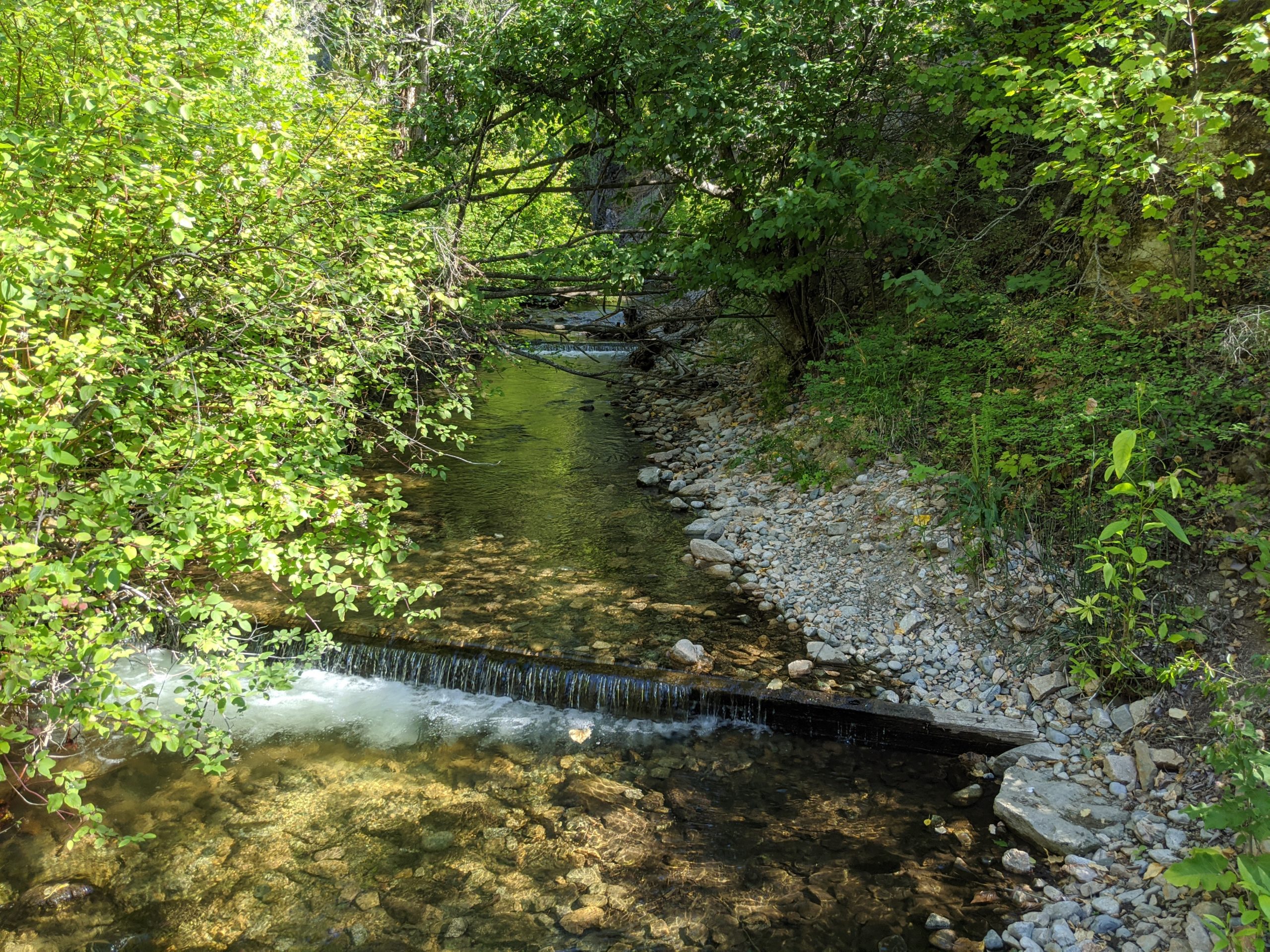
Photo courtesy of Ellen Spacey
Hardy Falls, named after Harry Hardy, who was one of the first orchardists on the west side of Okanagan Lake, is located at the south end of Peachland. It follows Deep Creek and leads to a beautiful waterfall. It is a short walk and easily accessible, making it one of Peachland’s most popular trails. Visit the falls in September to see the Kokanee salmon spawn. Make sure to check out the falls in the winter to see if they have frozen over!
Humans and their pets must stay out of the creek from August – May to avoid killing eggs, alevin and fry that are incubating and growing over the winter. Keep your eye out for black bears, especially when salmon are spawning. Respect their space and do not put yourself or the bear at risk for a photo opportunity.
Directions
The trailhead is located on Hwy 97 South at Hardy Street. Turn off Highway 97 onto Hardy Street and follow it to the parking lot.
Photos courtesy of the Regional District of the Central Okanagan.
Peachland Beach Rentals
What better way to explore Peachland than taking a cruise along Beach Avenue by bike? Sample Peachland’s flavours and take in the sights, then park your bike at the beach and relax! If you would prefer to explore Peachland by water, no problem— they rent paddleboards and kayaks too!
Available:
June 1st-30th
Thursday, Friday, Saturday, Sunday
10am to 7:00 pm
Wednesday, by appointment only
July 1st-August 31st
7 days a week (weather dependent)
10am to 7:00 pm
Pincushion Mountain Trail
Locals say that you can’t truly call yourself a Peachlander until you have summited Pincushion Mountain. One of the best known and most loved hikes, Pincushion Mountain is named after a wildfire in the 19th century that destroyed most of the trees on the mountain, leaving only burned trees that looked like pins. Today, Pincushion Mountain is very scenic, and it is a challenging, but rewarding hike. The top of Pincushion Mountain offers one of the best views in the Okanagan Valley. The trail begins with stairs and then becomes switchbacks. It has several steep sections, so proper footwear and even walking sticks are recommended. There are three look-out points that will allow you to rest before you hike to the summit. At the top, you’ll want to take an iconic selfie of the Canadian Flag and of the view. Then, sign the guestbook! The total hike has an elevation of 245 m.
The trail in spring can be hard to see if there is patchy snow still on the ground. If the area is still cold/icy, the trail will be slippery and in spring the mud will be slippery. In summer when the trail is dry the gravel is slippery. Be careful. The trail is well trod and there are trail markers— either bits of pink ribbon or old red signs high up on trees. Stay on trail as much as possible and be observant. It’s a totally worthwhile trek!
Directions
Travel on highway 97 south to Peachland. Take Ponderosa Drive and follow it to the end (there are a few possible turn offs— make sure you follow it to the end). Park in the Pincushion Mountain parking lot.
Learn more about this hike at www.hikingaddiction.ca
Photos courtesy of @grue_056 and HikingAddiction.ca
Stairway to Heaven
No need to buy a stairway to heaven— on this trail, you will ascend a whopping 158 stairs and trek a 1.5 km hike that is generally flat. This hike is a great option for folks who want to get outdoors but are on a tight schedule.
Directions
The trailhead is off a cul-de-sac on Victoria St. From Hwy 97, turn onto Princeton Ave. Follow Princeton and turn right onto Somerset Ave. Turn left onto Gladstone Road and another left onto Victoria St. There will be a half cul-de-sac along the right side. Park in an appropriate area not blocking any driveways.
Photo courtesy of Kristy Draginda, @hikingtheokanagan
Trepanier Creek Greenway Regional Park
This hike spans from Okanagan Lake waterfront to the Okanagan Connector Highway 97-C. It offers visitors a natural forest trail that borders the canyon of Trepanier Creek. From 1909 to 1947, there was a hydroelectric power plant on the creek that supplied our community. You can still see remnants of the Trepanier Creek dam.
The start of the trail is at the south end of the greenway. This is where the most challenging part of the hike is. The trail climbs continuously with some steep spots for 1500 m. Afterwards, the trail levels out and is fairly easy all the way to the Trepanier Rd. entrance. The footpath is wide with some narrow sections and consists of mostly natural materials. Please wear appropriate footwear and clothing and stick to the designated trails.
Directions
The trailhead is accessible via Clements Crescent (off Hwy 97 at the IGA) and is marked by Regional District signage.
Wilson Lake Ski and Snowshoe Trails
The Wilson Lakes snowshoe and ski trails showcase Peachland’s natural beauty. They were popular in the 1960s and 70s when the Peachland Ski Club existed. The trails are now being rediscovered. There is signage for the trailhead of the Wilson Lakes Loop. There is a 37 km trail system. Each trailhead is marked with colour-coded directional signs according to the ability required to ski it.
Trails and Distances (one way)
The Wilson Lake Loop: 5km – Easy
Wilson Silver Trail is 8km – intermediate
Fir Lane: 4km – Intermediate
Les’s Trail: 6km – Advanced
Aspen Grove Trail: 14km – advanced
Wes’s Trail, snowshoe to Wilson Mountain – 5km return
Warnings
These are not groomed trails, so please know your physical ability before heading out. Skiers and snowshoers share this trail together – please follow the etiquette posted on the signs. Be prepared for the wilderness – include a backpack, water bottle, snack and layered clothing. There is no cellphone service or amenities.
Directions
From highway 97 south in Peachland, turn onto Princeton Ave and continue following the road where it turns to gravel. At the fork, go right following the signs to Silver Lake Camp. Pass the turn off to Silver Lake. At 1.5km past the Silver Lake driveway, you will find Wes’s trail. Drive past this for another 3.5 – 4 km to the trailhead for the Wilson Lake loops. Trail signage is not visible from the road, so watch for cars parked on the side of the road or watch for a clearing where power lines are visible.